Purpose: Real-time crop analysis, field mapping, and reporting tools
Features:
- multispectral data to assess crop health
- offering actionable insights to improve yields
- 25-minute flight time.
- Real-time crop analysis, field mapping, and reporting tools
- Payload Capacity: 1.2 kg
- Camera: 14 MP with multispectral sensor
- Flight Time: 25 minutes
- Maximum Speed: 35 km/h
- Battery: 5,000 mAh Lithium Polymer
- Control Range: 3 km
- Sensors: Multispectral sensor, GPS
- Features: Real-time crop analysis, field mapping, reporting tools
- Weight: 1.8 kg
Base Price: ₹7,00,000 (~$8,284.44)
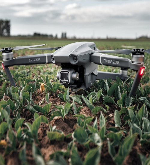
Sahadeva
The Sahadeva agricultural drone is a specialized tool designed for precision agriculture, making it ideal for farmers seeking to improve crop health and yields. With a compact 1.2 kg payload capacity, this drone is highly efficient in capturing crucial data without weighing down on its operations.
Equipped with a 14 MP camera and multispectral sensor, the Sahadeva drone captures high-quality images across different wavelengths. This enables it to assess the health of crops, identify stressed areas, and deliver actionable insights to farmers, enhancing productivity and crop management.
With a flight time of up to 25 minutes, Sahadeva can cover small to medium-sized fields in a single flight, ensuring minimal downtime and efficient operation. This makes it an excellent choice for farmers who need to monitor large areas while balancing battery life and performance.
The drone's maximum speed of 35 km/h makes it a practical solution for gathering data quickly across vast fields. This speed, combined with its accurate GPS system, allows Sahadeva to provide precise data for real-time crop analysis and mapping.
One of the standout features of the Sahadeva drone is its ability to offer real-time crop analysis. By using multispectral data, it can identify areas of a field that require attention, such as under-irrigated or over-fertilized zones, allowing farmers to make informed decisions.
With its field mapping capabilities, the Sahadeva drone creates detailed maps of crop health and conditions. These maps help farmers plan interventions with pinpoint accuracy, ensuring that resources are used efficiently and reducing waste.
In conclusion, the Sahadeva agricultural drone provides farmers with the tools to revolutionize their approach to crop management. Its advanced sensors, real-time analysis, and precise field mapping empower users to maximize crop yields while minimizing costs and environmental impact.