Purpose: Crop analysis, soil health monitoring, multi-spectral imaging.
Features:
- Precision mapping with multispectral sensors.
- Real-time data analytics for soil health.
- 25-minute flight time.
- Obstacle detection for safe navigation.
- Weight: 12 kg
- Payload Capacity: 8 kg
- Maximum Flight Time: 25 minutes
- Maximum Speed: 45 km/h
- Battery: 8,000 mAh Lithium Polymer
- Control Range: 4 km
- Camera: Multi-spectral camera
- Sensors: AI-driven navigation, GPS
Base Price: ₹7,00,000 (~$8,284.44)
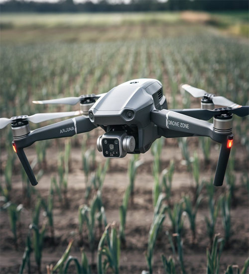
Arjuna
Arjuna drones are designed for advanced crop analysis and soil health monitoring, providing essential insights for sustainable farming. Featuring precision mapping capabilities, they create detailed maps that highlight areas needing attention, such as nutrient deficiencies or pest infestations. These drones boast a 25-minute flight time, allowing them to monitor extensive fields while maintaining operational efficiency. Multi-spectral imaging sensors help farmers understand various crop parameters, including moisture levels and vegetation health, facilitating targeted interventions.Arjuna drones offer an affordable yet sophisticated option for improving agricultural productivity. Their cutting-edge technology empowers farmers to maximize yield and reduce waste. Ideal for precision agriculture, these drones make data collection and analysis accessible and actionable.
agriculture drones can be programmed for autonomous flight, covering large areas in a fraction of the time it would take with traditional methods. This not only saves time and labor but also allows for more frequent monitoring, leading to timely interventions that can prevent small issues from becoming major problems. With the integration of AI and machine learning, these drones can analyze data more accurately, predicting trends and recommending actions to improve crop health and yield.
Drones equipped with multispectral cameras can capture detailed images of crops, helping farmers monitor plant health throughout the growing season. By analyzing these images, farmers can detect early signs of disease, nutrient deficiencies, and pest infestations. This allows for timely interventions, ensuring healthier crops and higher yields. The data gathered can also be used to create NDVI (Normalized Difference Vegetation Index) maps, which provide insights into crop vigor and growth patterns.
Drones play a crucial role in precision agriculture by enabling farmers to apply fertilizers, pesticides, and herbicides more accurately. With GPS-guided flight paths and variable rate technology, drones can target specific areas that need treatment, reducing the overall usage of chemicals and minimizing environmental impact. This not only enhances crop health but also leads to cost savings and more sustainable farming practices.
Before planting, drones can be used to conduct detailed soil and field analysis. By capturing high-resolution images and using sensors to measure soil moisture levels, drones provide valuable information on soil conditions and variability. This data helps farmers make informed decisions about crop placement, irrigation planning, and soil management, leading to better crop performance and resource efficiency.
Effective irrigation is vital for optimal crop growth, and drones can significantly enhance irrigation management. Equipped with thermal sensors, drones can identify areas of over- or under-irrigation by detecting temperature variations in the field. Farmers can then adjust their irrigation systems accordingly, ensuring that water is distributed evenly and efficiently. This not only conserves water but also prevents crop stress and improves yields.
Drones are also used for monitoring livestock, especially in large or remote areas. By providing aerial views of grazing patterns and herd movements, drones help farmers manage their livestock more effectively. Drones can also be equipped with thermal cameras to monitor the health and well-being of animals, detecting signs of illness or distress early on.